Análisis espacial
QUE HACEMOS
Realizamos investigación biogeográfica y ecológica mediante Sistemas de Información Geográfica y Percepción Remota en la Sierra Madre Occidental. Así como estudios de ecología térmica / We carry out biogeographic and ecological research using Geographical Information Systems and Remote Sensing in the Sierra Madre Occidental. As well as thermal ecology studies.
OBJETIVO
Generar conocimiento y conservación de la biodiversidad en la Sierra Madre Occidental (SMO) mediante técnicas de Percepción Remota y Sistemas de Información Geográfica /Generate knowledge and conservation of biodiversity in the Sierra Madre Occidental (SMO) using Remote Sensing techniques and Geographic Information Systems.
OBJETIVOS PARTICULARES
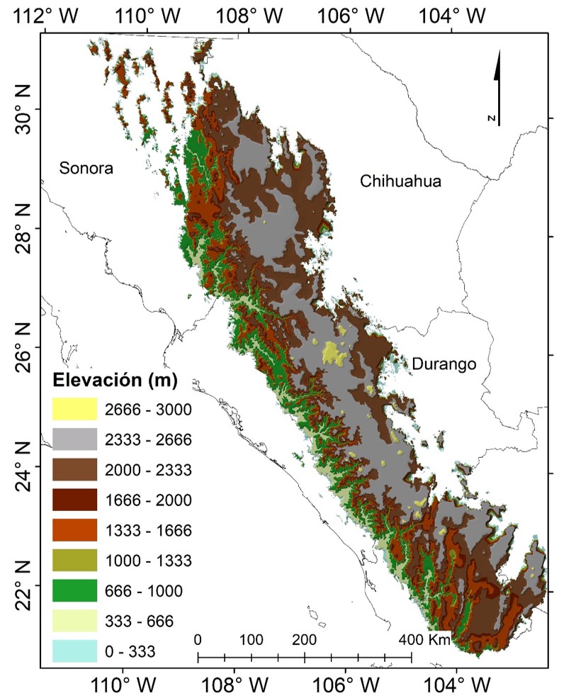
- Generar la cartografía digital de alta resolución para los tipos de vegetación de la SMO en cuatro etapas a lo largo de 10 años.
- Analizar la información disponible en las bases de datos de las colecciones del CIIDIR Durango y generar publicaciónes sobre regionalización biogeográfica de la SMO.
- Elaboración de mapas de distribución potencial de mamíferos de la SMO para proponer áreas de importancia para la conservación.
- Generar modelos de interacciones claves de especies de mamíferos.
- Publicaciones científicas y de divulgación con los resultados anteriormente descritos.
PERSONAL
La línea de investigación Análisis espacial inició al incorporarse al Laboratorio de Fauna Silvestre en octubre el 2016, la catedrática CONACYT: Dra. Sarahi Sandoval Espinoza. (SNI 1)
The research line Spatial analysis began when the CONACYT professor, Dr. Sarahi Sandoval Espinoza, joined the Wildlife Laboratory in October 2016.
PROYECTOS ACTUALES
- Sierra Madre Occidental: Mammals Hot Spots
- «Análisis multitemporal en Glaciares de México»/Multitemporal Analysis in Glaciers of Mexico
- Land surface temperature multitemporal analysis on the Sierra Madre Occidental
- «Actualización de la red hídrica en la Sierra Madre Occidental mediante Sistemas de Información Geográfica»/Updating the water network in the Sierra Madre Occidental through Geographic Information Systems
- «Mapas de distribución potencial de Flora y Fauna en la Sierra Madre Occidental»/Maps of potential habitat of Vegetation and wildlife in the Sierra Madre Occidental
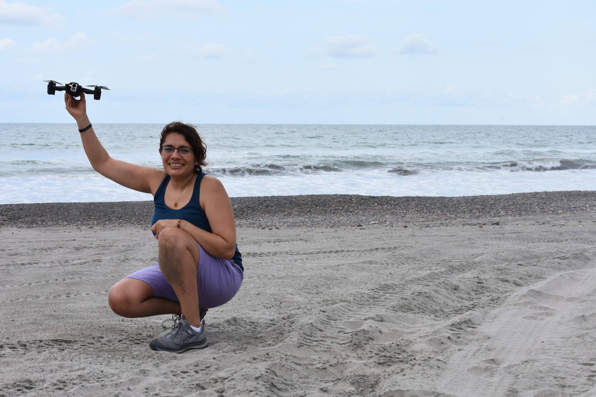
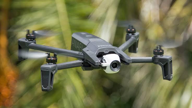
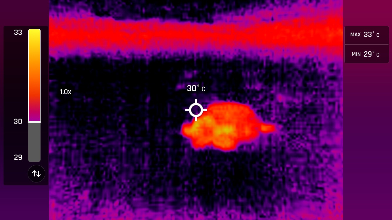
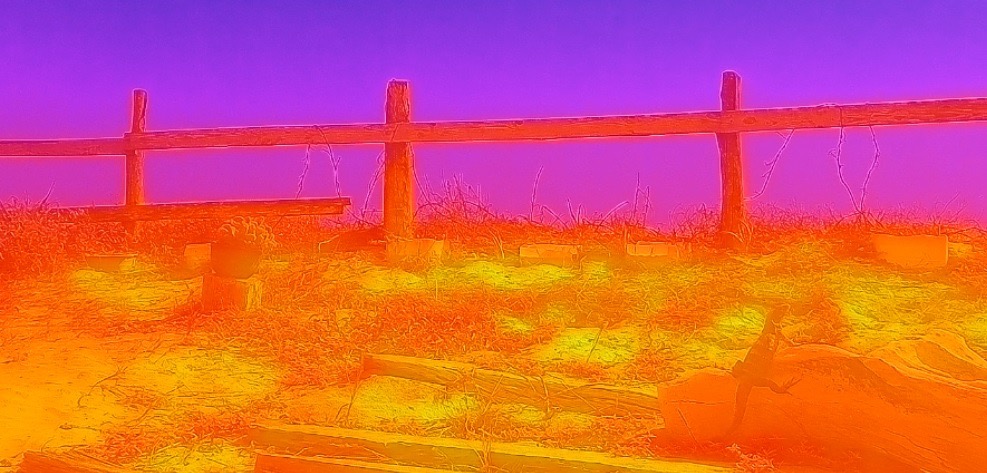
- «Detección de tortugas marinas mediante uso de Vehículos aéreos no tripulados con cámara térmica»/Detection of sea turtles using unmanned aerial vehicles with thermal camera
- Cambios en el área de la superficie de agua durante los últimos 30 años en Humedales Ramsar de Mexico mediante imagenes de satelite»/Changes in water surface area during the past 30 years in RAMSAR wetlands using Landsat data in the Sierra Madre Occidental
- Crecimiento urbano y su impacto con la temperatura superficial mediante SIG y Percepción remota»/Urban growth and its impact with surface temperature through GIS and Remote Sensing.
PUBLICACIONES
- Metabolic heat estimation of sea turtle Lepidochelys olivacea Sandoval S., Gómez-Muñoz V., Gutierrez J., Porta-Gándara M.A. (2011), Journal of Thermal Biology, 36(2), 138-141. http://www.seaturtle.org/PDF/SandovalS_2011_JThermBiol.pdf
- Parasitism of Cuterebra (Diptera: Oestridae) on rodents of island of the Gulf of California, Mexico. Gustavo Arnaud, Angel Rodriguez-Moreno, Amaury Cordero-Tapia, Sandoval S. (2016), Journal of Parasitology and Vector Biology. 8(9):92-98. http://www.academicjournals.org/journal/JPVB/article-full-text-pdf/2965AE060076
- Expansion of the transitional range of temperature for sea turtle Lepidochelys olivacea from sex ratio data at controlled incubation temperatures. Sandoval S., Víctor M. Gómez-Muñoz, Miguel Ángel Porta-Gándara. (2017). Herpetology Notes. 10:63-65. https://biotaxa.org/hn/article/view/23762
- Noteworthy record of the Kit Fox in the protected area Valle de los Cirios in Baja California, Mexico. Escobar-Flores J.G., Sandoval S. (2017). Therya. 8(1):79-82. http://www.revistas-conacyt.unam.mx/therya/index.php/THERYA/article/view/423
- Uso de aguajes por el principal ungulado cinégetico en Baja California. Escobar-Flores J.G., Sandoval S. (2017). Agroproductividad. 10(5):28-32. http://www.colpos.mx/wb_pdf/Agroproductividad/2017/AGROPRODUCTIVIDAD_V_2017.pdf
- Análisis de aptitud del hábitat del cerdo silvestre (Sus scrofa), mediante técnicas de Percepción Remota en Sierra la Laguna, Baja California Sur. Centro de Investigaciones Biológicas del Noroeste. Capítulo de Libro. Jonathan G. Escobar Flores, Arnaud G., Sandoval S. (2018). (Aceptado)
- Predicting Pinus monophylla forest cover in the Baja California Desert by remote sensing. Jonathan G. Escobar-Flores, Carlos A. Lopez-Sanchez, Sarahi Sandoval, Marco A. Marquez-Linares,Christian Wehenkel. (2018), PeerJ 6:e4603. https://peerj.com/articles/4603/
- Thermal ecology of the Rattlesnake Crotalus catalinensis from Santa Catalina Island, Gulf of California. Arnaud Gustavo, Sarahi Sandoval, Jonathan G. Escobar-Flores, Victor M. Gómez Muñoz, Jose L. Burguete. (2018). Acta Universitaria, 28: 1-8. doi: 10.15174/ au.2018.1667
- Waterhole detection using a vegetation index in desert habitat. Jonathan G. Escobar-Flores, Sarahi Sandoval, Raul Valdez, Eahsan Shahriary, Jorge Torres, Sergio Alvarez-Cardenas, Patricia Galina-Tessaro. (2019). PLoS ONE 14(1): e0211202. https://journals.plos.org/plosone/article?id=10.1371/journal.pone.0211202
- Análisis topográfico y climático de un bosque de pino detectado en una isla de montaña en Baja California. Sociedad Latinoamericana en Percepción Remota y Sistemas de Información Espacial (SELPER). Capítulo de Libro electrónico del XXII Congreso Nacional SELPER México. Sarahi Sandoval, Jonathan G. Escobar Flores, Cesar I. Hernández-Ramírez (2019). Aceptado
- A simple method for determining the sex of sea turtle hatchlings in protected nesting areas using temperature data. Sandoval S., Gómez-Muñoz V., Porta-Gándara M.A. (2020). (Aceptado)
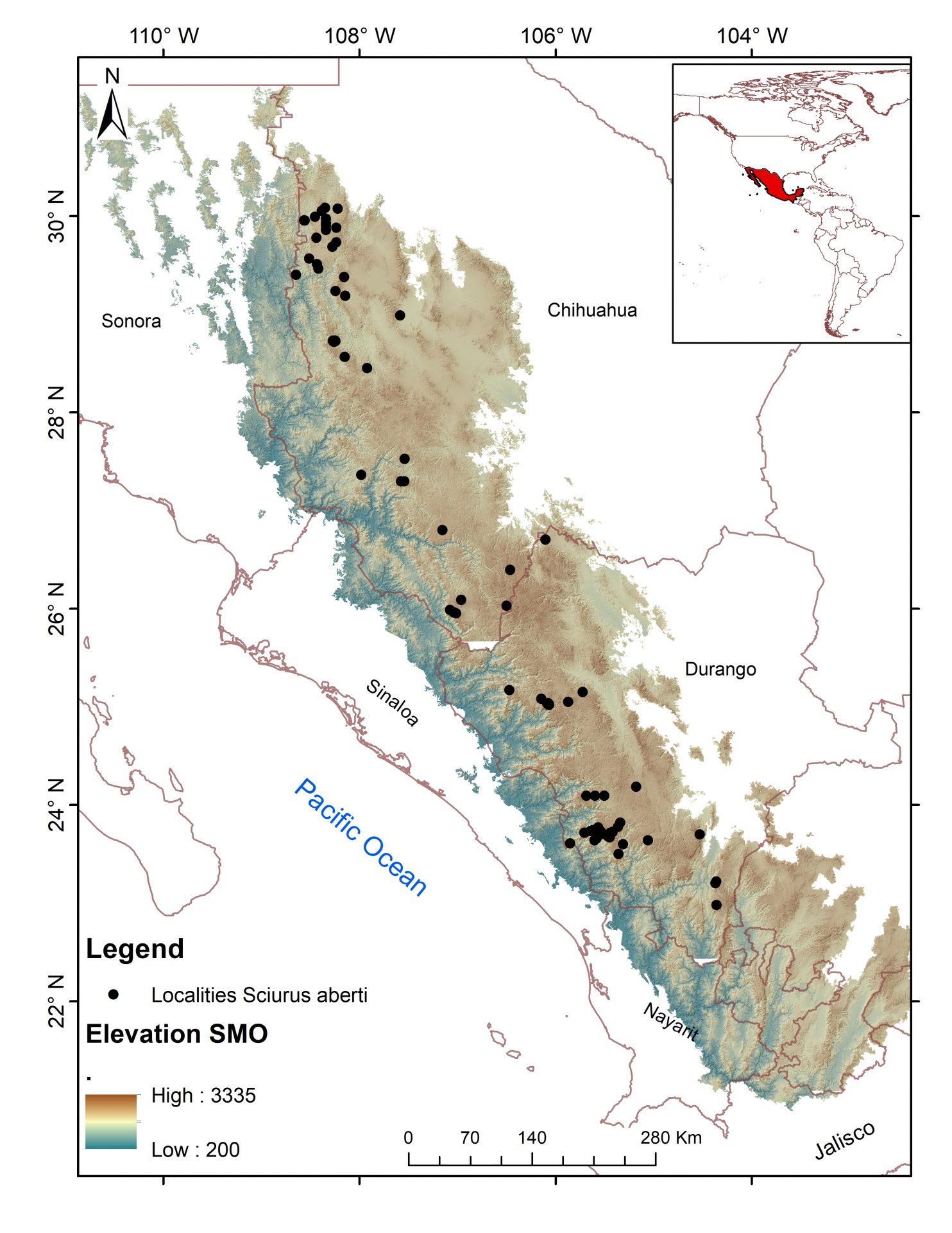
- Effect of spatial resolution, algorithm and variable set on the estimated distribution of a mammal of concern: the squirrel Sciurus aberti. Sarahi Sandoval , Celia López-González , Jonathan G. Escobar-Flores & Raúl O. Martínez-Rincón (2020): Écoscience, DOI: 10.1080/11956860.2020.1772609
- Water resource inventory from Sierra Madre Occidental based on Remote sensing and GIS. Sandoval Sarahi, Escobar-Flores J.E.,Sánchez-Ortíz E. (2020). http://www.investigacionesgeograficas.unam.mx/index.php/rig/article/view/59975/53477
- Análisis de la distribución temporal de Dodonaea viscosa (L. Jacq.) mediante técnicas de teledetección en Durango, México. Marquez-Linares, Marco, A.; Escobar-Flores, Jonathan G.; Sarahi Sandoval; Perez-Verdín, Gustavo. (2020). 2020. Agroproductividad. 13(8): 61-67.
- Unmanned aerial vehicle (UAV) for sea turtle skeleton detection in the Mexican Pacific
J.G. Escobar-Flores, Sarahi Sandoval (2021). Remote Sensing Applications: Society and Environment. https://doi.org/10.1016/j.rsase.2021.100501 - Changes in water surface area during the past 30 years in a Ramsar Wetland in Durango, Mexico using Landsat data. (2021) Sarahi Sandoval., J.G. Escobar-Flores. IGARSS. IEEE International Geoscience and Remote Sensing Symposium.
- Modelling potential distribution of the endemic ringtail ( Bassariscus astutus saxicola) on an island in the Gulf of California
Gustavo Arnaud, Sarahi Sandoval, J.G. Escobar-Flores, R. Sansores-Sánchez. (2021). Agroproductividad. 14(6): 1-9. - Multitemporal analysis of a glacier in central Mexico: Iztaccihuatl-Popocatepetl National Park during the last 36 years. Sarahi Sandoval. (2022). IGARSS. IEEE International Geoscience and Remote Sensing Symposium.3947-3950 pp. https://ieeexplore.ieee.org/document/9883993
- Artificial intelligence to model the potential distribution of (Agave durangensis). Escobar-Flores, J. G. , Sarahi Sandoval. (2022). IGARSS. IEEE International Geoscience and Remote Sensing Symposium. 5828-2831 pp. https://ieeexplore.ieee.org/document/9883767
- Hydrographic Network from High Spatial Resolution Remote Sensing Data: A Case Study in the Sierra Madre Occidental. Sarahi Sandoval (2023). Submitted
- Unmanned aerial vehicle images in the machine learning for agave detection. Escobar-Flores J. G. , Sarahi Sandoval (corresponding). (2022). Environmental Science and Pollution Research. https://doi.org/10.1007/s11356-022-18985-7
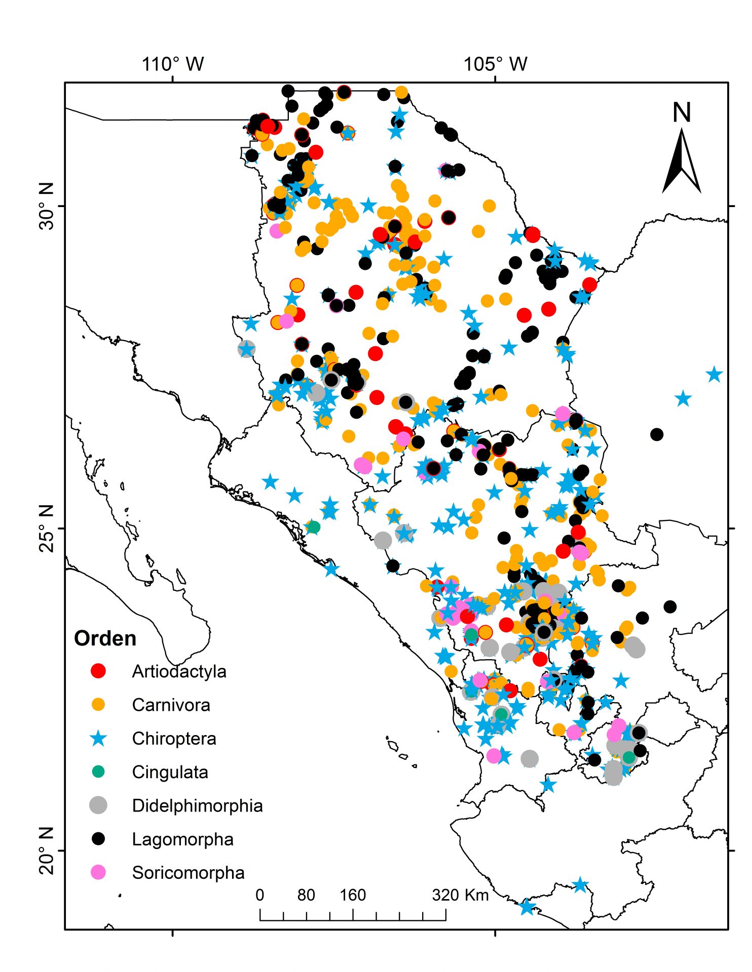
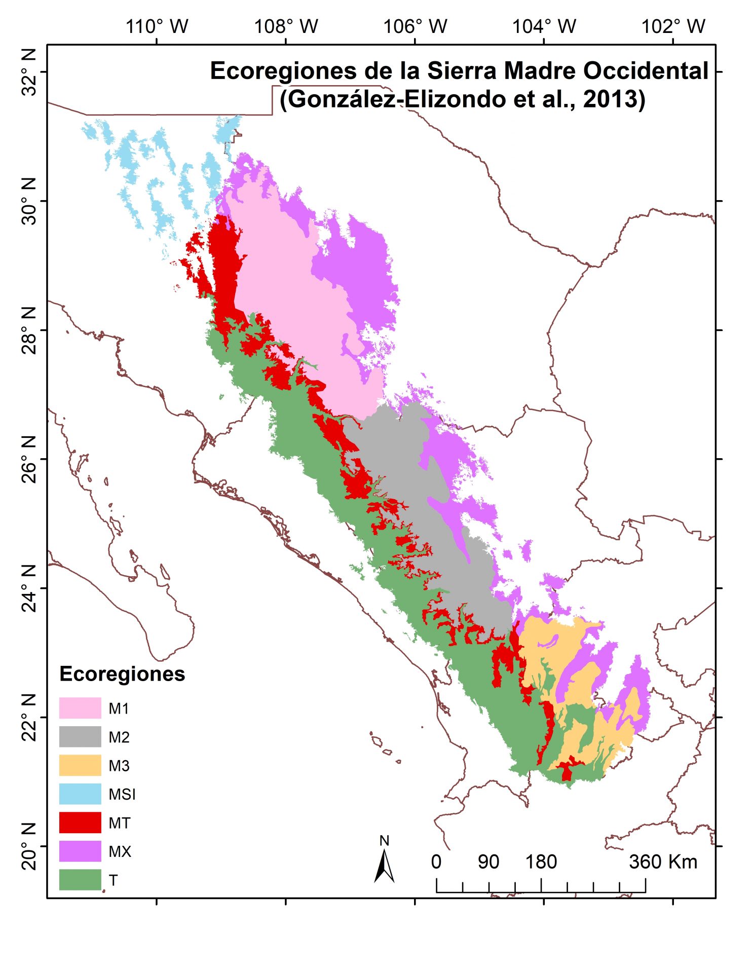
- An ecoregionalization of the Sierra Madre Occidental, México, based on non-volant, small mammal distributions. López González C., Sarahi Sandoval, Escobar-Flores J. G. (2023). Écoscience. 30(1): 65-81. https://www.tandfonline.com/doi/full/10.1080/11956860.2023.2207947
- Land surface temperature and urbanization in a tourist region in Mexico over the last three decades. Submitted.
GEOINFORMACIÓN
- Cuerpos de agua Sierra Madre Occidental. https://www.dropbox.com/sh/6rfxi47ii8q6jkx/AAB5MWqMBCFvisiboX_m86LTa?dl=0
- Script en MATLAB para el cálculo de la Proporción sexual en crías de tortugas marinas. https://drive.google.com/drive/folders/1beq9keJU6fZB5PHj6KCdXnhUFIdfxaXa
CURSOS IMPARTIDOS
- Participante de la Materia «Geomática» , para alumnos de posgrado en el Instituto Politécnico Nacional, Unidad Durango. Semestre Enero- julio 2023.
- Participante de la Materia «Geomática» , para alumnos de posgrado en el Instituto Politécnico Nacional, Unidad Durango. Semestre Agosto- Diciembre 2022.
- Profesor en curso «Introducción a la programación en MATLAB» en CIIDIR- IPN. Unidad Durango. Noviembre 2022.
- Participante de la Materia «Geomática» , para alumnos de posgrado en el Instituto Politécnico Nacional, Unidad Durango. Semestre Agosto- Diciembre 2021.
- Participante de la Materia «Geomática» , para alumnos de posgrado en el Instituto Politécnico Nacional, Unidad Durango. Semestre Febrero – Julio 2021.
- Participante de la Materia «Geomática» , para alumnos de posgrado en el Instituto Politécnico Nacional, Unidad Durango. Semestre Septiembre-Febrero 2020.
- Participante de la Materia «Geomática» , para alumnos de posgrado en el Instituto Politécnico Nacional, Unidad Durango. Semestre Enero- Julio 2020.
- Profesor en curso «Introducción a la programación en MATLAB» en CIIDIR- IPN. Unidad Durango. Noviembre 2018.
- Participante de la Materia «Geomática» , para alumnos de posgrado en el Instituto Politécnico Nacional, Unidad Durango. Semestre Enero- Julio 2018.
- «Inmersión al mundo de MATLAB» para alumnos de posgrado en la Universidad Nacional Autónoma de México, Instituto de Ciencias del Mar y Limnología de la Unidad Académica de Sistemas Arrecifales Puerto Morelos. 2014.
CONTACTO
Dra. Sarahi Sandoval Espinoza
mail: sarahisandovale@gmail.com
ALUMNOS/STUDENTS
Maestría/ Master Degree
2023
| Alumno/ Institución | Titulo de tesis | |
|---|---|---|
|
nnnnn |
Alfonso Gaytan Alarcon
IPN CIIDIR Durango
|
Análisis multitemporal del cambio y uso de suelo de la Reserva de la Biosfera Marismas Nacionales mediante teledetección
|
| Alumno/ Institución | Titulo de tesis | |
|---|---|---|
 |
Roman Reyes Carillo
IPN CIIDIR Durango |
«Diagnóstico de riesgo de la actividad minera de la cuenca del río Presidio al San Pedro» /Risk diagnosis of mining activity in the Presidio al San Pedro river basin
Estatus: Tesis terminada (2018-2020). Graduado. |
 |
Marina Jiménez Jiménez
CIBNOR B.C.S. |
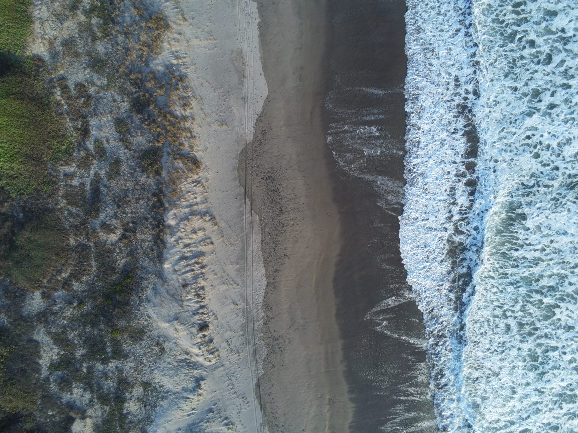
«Temperatura superficial de la arena en áreas de anidación de tortuga marina mediante teledetección»
Estatus: Tesis terminada (2021-2023). Graduado.
|
Tesis Licenciatura
2019-2021
| Alumno/ Institución | Titulo de la Tesis | |
|---|---|---|
 |
María Ángeles Hurtado Telles
IPN Zacatecas |
«Evaluación de la expansión urbana y su impacto con la temperatura superficial mediante SIG y Percepción remota»/Evaluation of urban sprawl and its impact with surface temperature using GIS and Remote Sensing
Status: Tesis terminada. Diciembre 2021. Graduado. |
 |
Elvia Rosa Jiménez Morales
Universidad Autónoma Chapingo |
«Análisis multitemporal de glaciares en México «/Multitemporal analysis of glaciers in Mexico
Estatus: Tesis terminada. Graduado. |
Residencias profesionales
2018
| Nombre del alumno | Titulo de informe | |
|---|---|---|
 |
Fernanda D. Beltrán García
Universidad Politécnica de Durango |
“Detección y caracterización de humedales prioritarios para aves acuáticas de la Sierra Madre Occidental usando Percepción remota”
Estatus: Concluida. |
 |
Edgar Adrián Correa Cepeda
Universidad Juárez del Estado de Durango |
“Detección actual de cuerpos de agua por imágenes de satélite Sentinel-2 del sur de la Sierra Madre Occidental”.
Estatus: Concluida. |
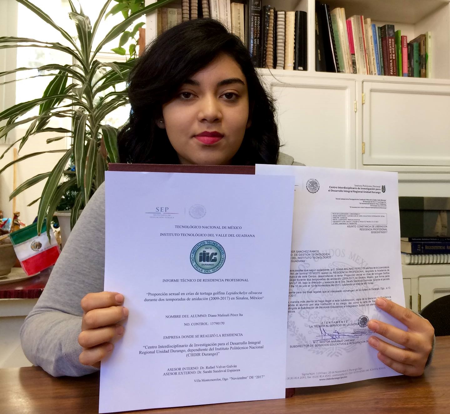 |
Malinali Perez Ita Instituto Tecnológico del Valle del Guadiana |
“Proporción sexual en crías de tortuga golfina Lepidochelys olivacea durante dos temporadas de anidación (2009-2017) en Sinaloa, México”/Sex ratio in olive ridley sea turtle hatchlings Lepidochelys olivacea during two nesting seasons (2009-2017) in Sinaloa, Mexico
Estatus: Concluida. |
CURSOS
- «Procesamiento de Imágenes satelitales con ENVI» ..Impartido por Master SIG Peru. 2020.
- » Curso de Hidrología de Cuencas con ArcGIS.. Impartido por Master SIG Peru. 2019.
- » Curso de Latex»… 2019.
- » Curso Completo de MATLAB (Básico, Intermedio y Avanzado). Impartido por Ing. Jesus Ernesto Valdez Almaral, experto en Machine Learning Image Processing. En curso 2019.
- » Learning English Gradually. Nivel intermedio. Impartido por Elba Calderón, experto en Teacher of English and Writer Method L.E.G. 2018.
- » Curso Completo de ARCGIS (Básico, Intermedio y Avanzado). Impartido por Master SIG Peru. 2018.
- «Introducción a la Percepción Remota», impartido CIIDIR-IPN Durango, con duración de 40 horas. 2017.
- «Introducción a la Percepción Remota», impartido en la Universidad Juárez del Estado de Durango, con duración de 21 horas.2016.
- «Introducción al uso y representación geoespacial», impartido por CENTROGEO, con duración de 40 horas. 2017.
- «Introducción a R», impartido en CIIDIR – IPN Durango, con duración de 25 horas. 2017.
OPORTUNIDAD PARA TESIS DE LICENCIATURA
PROYECTO: Aplicación del SIG y Percepción remota para generar conocimiento de la Sierra Madre Occidental.
SIMPOSIOS
IEEE International Geoscience and Remote Sensing Symposium (IGARSS) , Septiembre 2020.
2a Reunión Internacional sobre Tortugas Marinas del Pacífico Oriental y 5a Reunión Nacional sobre Biología y Conservación de Tortugas en México. Michoacán, 2019.
XVIII Congreso Internacional y XXIV Congreso Nacional de Ciencias Ambientales, Mazatlán, 2019.
XXII 1a Conferencia Nacional sobre Manejo y Conservación de Fauna Silvestre, San Luis Potosí, México 2018.
Foro Internacional Forestal Durango. México. 2018.
65th Meeting of the Southwestern Association of Naturalist , San Marcos, USA, 2018.
XXII Congreso Nacional SELPER-México, Guanajuato, México, 2017. VII Simposio Tópicos Biológicos, Durango, México, 2017.
64th Meeting of the Southwestern Association of Naturalist , Oklahoma, USA, 2017.
XIII Congreso Nacional de Mastozoología , Chiapas, México, 2016.
Talleres y I Congreso Nacional sobre Serpientes y Ofidismo, Nuevo León , México, 2016.
36th International Symposium on Sea Turtle Biology and Conservation, Lima, PERU, 2016.
CONTACTO
Dra. Sarahi Sandoval Espinoza
mail: sarahisandovale@gmail.com cv-MARIO